RAVEN WEBB INTEVIEW ON KHEN: TRUTH QUEST TALK RADIO SHOW FROM SALIDA, COLORADO
Raven's tells the story of the intentional flooding of her home caused by fraudulent environmental NGO's in Wahkiakum County on Truth Quest radio show. This interview is archived and available for listening.
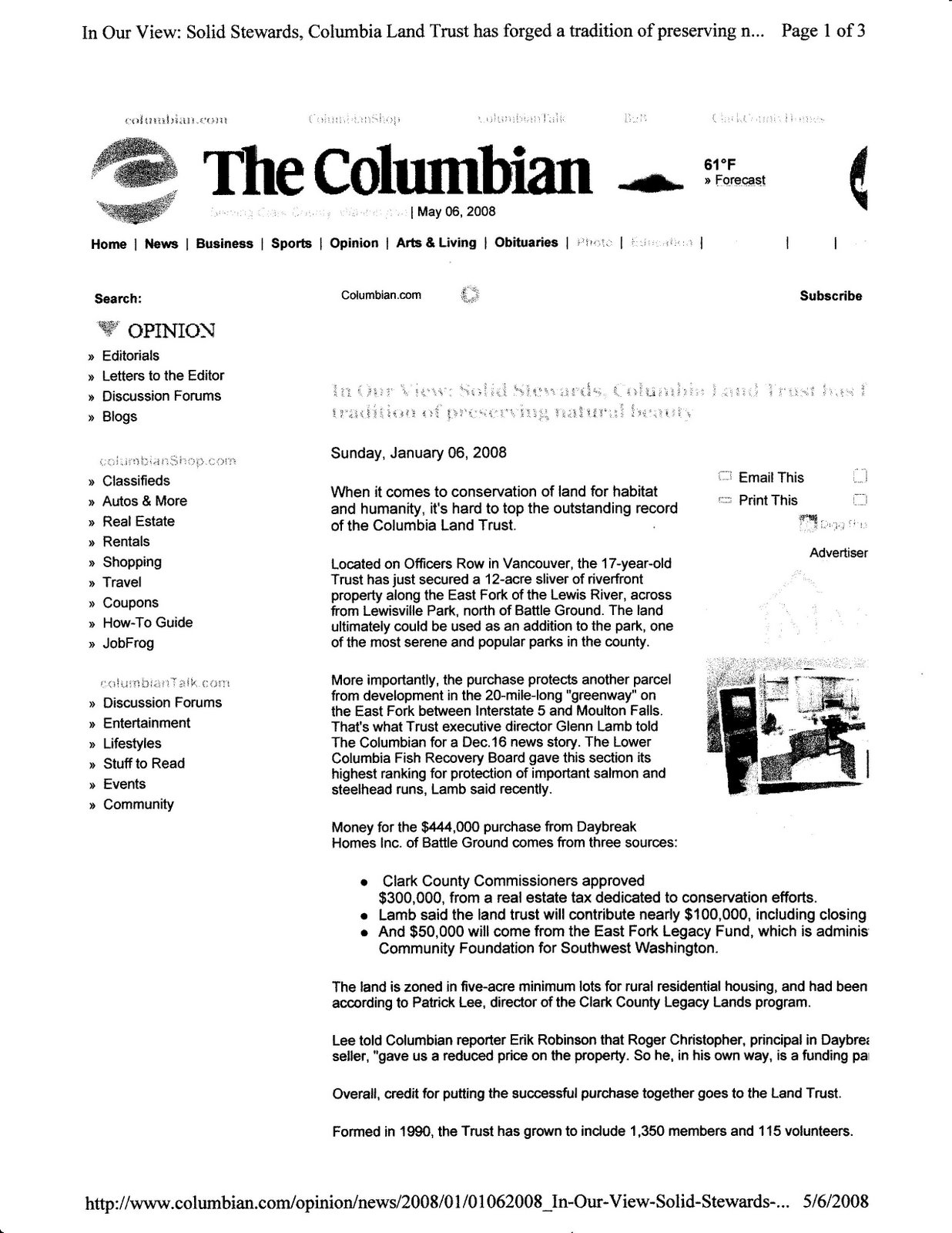
We have been getting some truth in the media as of late. Copied from Wahkiakum Eagle
Although some of the dates are wrong the article covers the situation truthfully.
October 29, 2008
Restoration work puts land owners under siege by Stevan Morgain
War comes in different forms, some violent, some psychological and quiet. The effect along the GraysRiver? Property owners are feeling under siege.
“We are trying to save our properties,” said Delvin Fredrickson, chairman of the Grays River Habitat Enhancement District (a diking district) “from non governmental organizations (NGOs) like The Columbia Land Trust, Ducks Unlimited, the Lower Columbia Fish Recovery Board, and the Columbia River Estuary River Study Taskforce.” Fredrickson points out that the conservation groups invading the GraysRiver are using fish mitigation dollars from the Bonneville Power Administration (BPA) to change the flow patterns of GraysRiver and, in the process, destroying property values and the tax base. Fredrickson said his community is fighting for their property rights. He is also frustrated with his US Representative Brian Baird and countyCommissioner Dan Cothren for not standing up to the NGO groups.
The problems began in 2006 (should be 2004) when the environmental groups Columbia Land Trust and Ducks Unlimited built their first project on Kandoll Road in Western Wahkiakum.
The Kandoll Road story isn’t new. The project is a quarter of a mile long dike and two 13-foot culverts installed by The Columbia Land Trust and Ducks Unlimited across a county easement in a cow pasture on the old Kandoll Dairy Farm. In the winter floods of 2006, water was trapped behind the dike and 18 properties up and down that section of the Grays suffered significant damage to homes, property and livestock.
“First we want the Kandoll Road dike and culverts removed so the water can flow the way it has for a hundred years,” said Fredrickson.
The Columbia Land Trust has a different take on the work they do. In an interview earlier this year, Columbia Land Trust Stewardship Manager Ian Sinks said, “We do the work of a land trust. We work with landowners according to the goals of the landowner and Columbia Land Trust. ”Sinks said several owners in GraysRiver offered their land for sale. The land trust also controls about 20,000 acres of land in WahkiakumCounty.
“Our goal is not to take land out of production but look at the land and where the land wants to be something else, and allow that to happen,” said Sinks. “This argument has gone nowhere for five years and created a lot of distrust and controversy over groups like The Columbia Land Trust and Ducks Unlimited,” said Wahkiakum County Commissioner Blair Brady, “but in fact the Bechtel engineering map produced for the Kandoll project does show a 'bathtub' effect where water backs up behind the dike.”
The Kandoll Road fiasco was the first shot across the bow of a citizen’s rights battle that continues inflame GraysRiver residents. In May of this year, the Lower Columbia Fish Recovery Board (LCFRB) asked the GraysRiver community for a town meeting to discuss their proposed plan for the GraysRiverValley. Presented to the Grays River community as The Habitat Restoration and Project Design Study, the plan looks at 62 sections of the Grays, about 18 miles long, and suggests tidal slough restoration, riparian restoration, dike breaching, channel enhancement, tributary enhancement, side-channel and floodplain restoration, bank sloping and adding log jams and woody plant debris to selected areas of the river. “I was there, and their plan isn’t a commitment for these jobs to be done,” said Brady. “It is basically a guide for anyone who wants to use private funds or public grants to do work in the river.” Under the plan’s Design Needs section, it notes landowner outreach. The question asks potential grant applicants to determine if landowners will let them onto their land to do topographic surveys, hydrologic/hydraulic analysis, sediment evaluation and conduct detailed engineering designs of their land.
With the property damage from the Kandoll Road project still on their minds, GraysRiver residents attended the meeting organized by the LCFRB. “There were about 50 or 60 people at the meeting in Grays River and they were all very upset because the LCFRB plan involved breaching dikes and flooding private properties of people who hadn’t even been consulted,” said Brady. Fredrickson said the plan presented at the meeting would effectively drive most of the GraysRiver’s lowlanders from their homes along the river. “Don’t get me wrong,” he said, “we want to stop the flooding here but their proposal will only make things worse."The Grays River Habitat Enhancement District’s research paints a clear picture of why the GraysRiver floods. It starts with the US Army Corps of Engineers dredging of the ship channel at the mouth of the GraysRiver. “Their dredging has shifted the strong currents that once flushed the mouth of the Grays, out to the center of the Columbia and into the shipping channel,” said Fredrickson. That one problem causes the mouth of the Grays to clog up and become shallow which then ripples back upriver for about 18 miles. Commissioner Brady agrees with Fredrickson’s assessment that the Grays’ riverbed has raised about 12 feet in the last 90 years. “I have to agree,” said Brady. “If you want to stop the flooding you have to stop the silt and debris from staying in the river and you can’t do that by installing more barriers that will trap even more debris.” Then there is logging. Logging dumps soil and woody debris into an already slower running GraysRiver. “The logging companies don’t replant, the soil gets loosened and washed into the Grays which adds to the build up,” said Fredrickson.
The situation gets magnified when the conservationists come along. “They want to tear down 100-year old dikes and add gravel, log jams and add new channels to an already overburdened river which will then cause even more water to backup into the Gray's feeder streams and cause yet more flooding,” said Fredrickson.
The LCFRB said the grants it offers are to groups who want to restore the river to its natural flow. Their plan for the GraysRiver designates the construction of side-channels, ponds and sloping banks. “Our group has surveys,” said Fredrickson, “and legal descriptions and testimonials going back to the 1850’s that show this river was a dynamic flow river, meaning it didn’t have the tributaries talked about in the LCFRB plan.” Fredrickson said that the mouth of Grays River wasn’t silted shut previously and during the freshet season ,the river often raged down through the valley.“That’s what kept the riverbed flushed out for fish and people,” he said. To prove his point Fredrickson produced a photograph of the old GraysRiver store (now Duffy’s Irish Pub) with about a 60’ scow docked in front of it. “This is how deep and wide the river used to be,” he said.
As wars go the Grays has escalated as the folks living in the area become more aware of the LCFRB’s plans for their community, and more frustrated. After feeling ignored by Wahkiakum County Commissioners over the Kandoll Road issue, in 2006 the Grays River Habitat Enhancement District contacted State Representative Mark Doumit who then wrote to the State Fish and Wildlife Department asking them to help resolve the Kandoll Road problem. In his reply to Representative Doumit, former Fish and Wildlife Director Jeff Koenings said, “No one likes to see people lose their homes.... However, our position is to allow the GraysRiver to run its natural course. Unfortunately, allowing the river to restore itself will affect landowners." “It doesn’t have a natural course anymore,” said Fredrickson, “but what that letter means is the government doesn’t give a damn about what’s happening to us, so now we have to fight our own government who uses our tax dollars to hire NGOs who in turn are being allowed to destroy our land.”
Fredrickson said the way it works is subtle. People pay their federal taxes and electric bills. Some funds are placed into the Bonneville Power, and the Fish and Wildlife’s fish mitigation funds. These agencies then turn around and hire an organization like the LCFRB to collect conservation grant proposals from tribal governments, state agencies, property owners, private conservation groups, and other Federal agencies.
When returned, the proposals collected from organizations like Ducks Unlimited or the Columbia Land Trust get reviewed and ranked according to areas of importance. The Lower Columbia Fish Recovery Board then either approves or rejects the grant applications based on the ranking.
Next, in the case of critical areas, the law governing these areas kicks in, and the Department of Fish and Wildlife gets involved. This places the force of law on the side of the NGO. It also places the burden of proof on those who disagree with the conservationists' efforts to return the land to its natural state, like the folks in GraysRiver whose only recourse now is through the court system. “If this fight is about anything, it’s about people's rights to decide what happens to their lives and their properties,” said Fredrickson. “We’re not rich but we have constitutionally guaranteed property rights.” Fredrickson said if the state and county governments won’t help mitigate the problems the community is having with the conservation groups coming in and taking over, then they plan to escalate the fight by calling in reinforcements such as the national organization, Citizens Alliance for Property Rights.
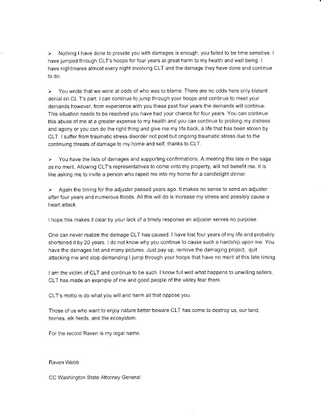
Columbia Land Trust’s Glen Lamb has responded with we are not to blame which is his take all along.


No comments:
Post a Comment